Trail Walking La Trinité - Les Tours de Montmayeur au départ de la Trinité via col de Cochette - Photo

Les Tours de Montmayeur au départ de la Trinité via col de Cochette

 ranchoup
ranchoup

User

© OpenStreetMap contributors
Length
Length
12.9 km
Max alt
Max alt
797 m
Uphill gradient
Uphill gradient
548 m
Km-Effort
Km-Effort  
20 km
Min alt
Min alt
334 m
Downhill gradient
Downhill gradient
548 m
Boucle
Boucle
Yes
Creation date :
2022-04-12 08:21:02.116
Updated on :
2022-04-12 16:15:48.897

(0 Reviews)

Walking
Walking
4h44
Difficulty : Easy

Scan this QR Code to open this trail in the SityTrail application

FREE GPS app for hiking

Logo SityTrail SityTrail

IGN / Geographical institutes

Download SityTrail from the App Store Download SityTrail from Google Play

Logo SityTrail SityTrail World

The world is yours!

Download SityTrail from the App Store Download SityTrail from Google Play Download SityTrail on Huawei AppGallery

About

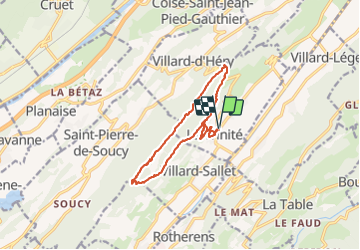
Trail Walking of 12.9 km to be discovered at Auvergne-Rhône-Alpes, Savoy, La Trinité. This trail is proposed by ranchoup.

Description

Départ du parking de l'église de la Trinité.
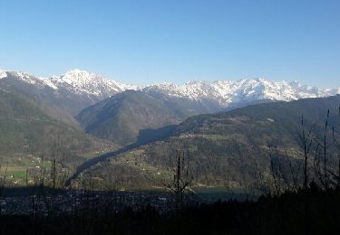
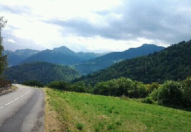
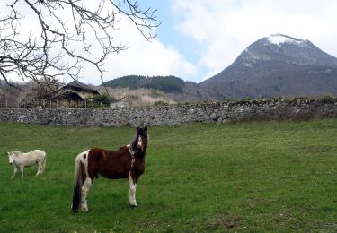
Jolie rando assez facile sur des chemins et routes forestières agréables. Vues sur Belledonne d'un coté et sur les Bauges de l'autre.

Elevation profile

Photos

Positioning

Country:
France
Region :
Auvergne-Rhône-Alpes
Department/Province :
Savoy
Municipality :
La Trinité
Location:
Unknown
Start:(UTM)
277146 ; 5042179 (32T) N.

Trails nearby

Trail Mountain bike Valgelon-La Rochette - plan perrier + montmayeur - Photo
Mountain bike
jbmathi

Mountain bike

Medium
(1)
Valgelon-La Rochette, Auvergne-Rhône-Alpes, Savoy, France
25 km | 34 km-effort
2h 49min
Yes
Trail Walking La Trinité - les Tours de Montmayeur  - Photo
Walking
GuyVachet

Walking

Difficult
La Trinité, Auvergne-Rhône-Alpes, Savoy, France
16.3 km | 24 km-effort
6h 27min
No
Trail Mountain bike Valgelon-La Rochette - brame farine - Photo
Mountain bike
tophe73

Mountain bike

Medium
Valgelon-La Rochette, Auvergne-Rhône-Alpes, Savoy, France
35 km | 52 km-effort
2h 47min
Yes
Trail Cycle Valgelon-La Rochette - Plan Perrier - Photo
Cycle
jbmathi

Cycle

Easy
(1)
Valgelon-La Rochette, Auvergne-Rhône-Alpes, Savoy, France
17 km | 24 km-effort
1h 22min
Yes
Trail Mountain bike Valgelon-La Rochette - Prodin VTT - Photo
Mountain bike
jbmathi

Mountain bike

Difficult
(2)
Valgelon-La Rochette, Auvergne-Rhône-Alpes, Savoy, France
35 km | 53 km-effort
Unknown
Yes
Trail Road bike Valgelon-La Rochette - col de la cochette depuis la rochette - Photo
Road bike
scalpy

Road bike

Very difficult
Valgelon-La Rochette, Auvergne-Rhône-Alpes, Savoy, France
32 km | 42 km-effort
2h 22min
Yes
Trail Walking Cruet - Cruet-2021-03-22 - Photo
Walking
Valmeinier

Walking

Easy
Cruet, Auvergne-Rhône-Alpes, Savoy, France
7.7 km | 13.9 km-effort
3h 9min
Yes
Trail Walking Cruet - Col-Marocaz-2021-03-21 - Photo
Walking
Valmeinier

Walking

Medium
Cruet, Auvergne-Rhône-Alpes, Savoy, France
11.3 km | 20 km-effort
4h 34min
Yes
Trail Walking La Table - 26 juin 2020 previeux - Photo
Walking
Parodie69

Walking

Medium
La Table, Auvergne-Rhône-Alpes, Savoy, France
16.8 km | 31 km-effort
6h 20min
Yes


Close
My subscriptions